Showing posts with label photographs. Show all posts

Saturday, February 10, 2018

The future of Dorchester County: High Tide

Here's a video regarding the trend and fate of Dorchester County.  Multiple images of Cambridge are included.

Yes, that's Deep Harbour and the Municipal Marina.

"High Tide in Dorchester" from Chesapeake Bay Journal on Vimeo.
The video is available for your viewing pleasure at https://vimeo.com/252911985 

If you like this video, make sure you share it, too!


December, 2012

Saturday, December 9, 2017

900 Marshy Cove: SAVE THE DATE: Holiday Party

SAVE THE DATE: Holiday Party
Saturday, December 16, 2017,
 4:00-6:00 PM

Prepare to celebrate the Holidays!


Hors d'oeuvres and beverages from 4-6 PM in the lobby.
Meet your friends and make some new friends.
All residents, owners, and tenants are invited.

Questions?  Send them to mc900@comcast.net


Sunday, February 19, 2017

DNR completes Rail Lift for large vessels


In case you have been wondering what has been going on across the creek.
The DNR has been rebuilding the rail lift ramp that will enable them to service their fleet here in Cambridge.  
The project started last summer when the ramp was partitioned with temporary steel pilings.
The water was pumped out creating a dry work space.  The original wooden pilings an rails were replaced. In the past three weeks, the large crane returned to remove the steel pilings. 

Response to an email sent to the DNR
~~~~~~~~~~~~~~~~~~~~~~~~~~~~~~~~~~~~~~~~
Dear Sir:

Thank you for contacting the Maryland Department of Natural Resources regarding the work in Cambridge Creek.

The department's Engineering and Construction Unit has replaced the railway that we use to pull boats out of the water for repairs. The next phase of the project includes replacing the bulkhead. This a very important facility for the department because we use it to house equipment and materials, including our ice breaker.

Thanks again for writing the department. If you have any additional comments or questions about the project, please contact Jordan L. at the Maryland DNR

Thanks,
Stephen
MD Logo.png

facebook_logo.jpg twitter_logo.jpg
Stephen E. Schatz
Director, Communications
Department of Natural Resources
580 Taylor Ave., D-4
Annapolis, Maryland 21401


It appears that the work is done.
The DNR Ship Maintenance Facility. Big Lou, the tug, is docked above the rail ramp.


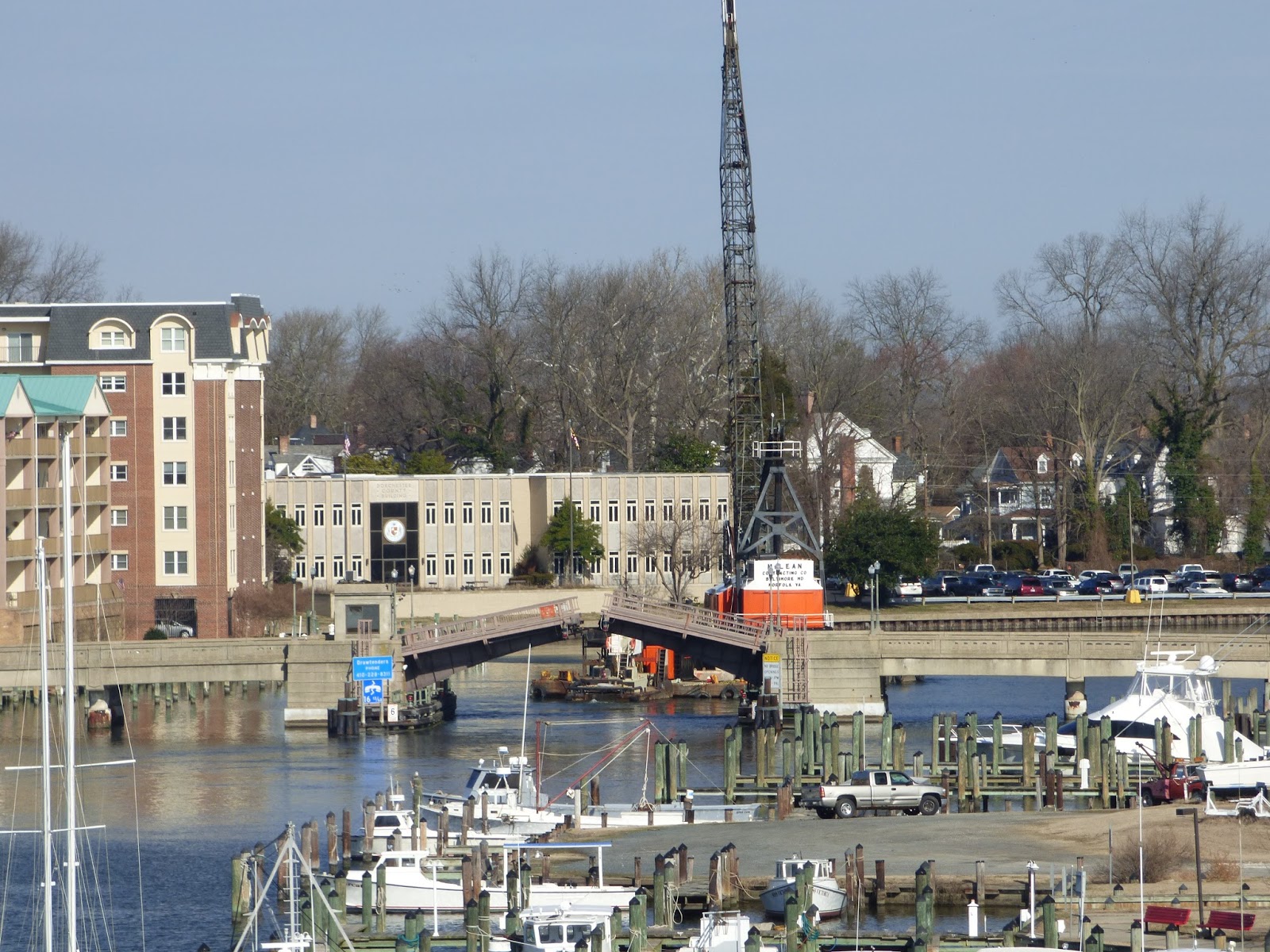
The large crane needed to place and remove the steel bulkhead pilings heads out to the Choptank

A tight fit, a slow approach held up street traffic for 20 minutes


Safely on the north side


Tuesday, May 31, 2016

5th Annual Deep Harbour Rockfishing Trip

Many thanks to all that came for another beautiful day on the Chesapeake.
We caught our limit despite a slow start in the early morning.
How about that 5 at once episode? twice?
See you next year, Stand-by for a Monday in Trophy Season.
The date will be posted on this site.
George 
Joe & Dave wait their turn
John on watch 
Dave and Dave: same name, different people.
Leo. happy after catching a fish
peace on the water
George, yes that's me.
Phil at work  
The limit!
The catch
Captain Perry never stops working.

 Some were interested in planning a crabbing trip. Maybe in the early fall?


See the Deep Harbour site

Tuesday, March 29, 2016

900 Marshy Cove Resident Selected By Cambridge Main Street


Local photographer Jameson Harrington has been selected to be the first photographer to showcase work on Cambridge Main Street's new website, which will be unveiled at its annual fundraising Spring Fling fundraising event on April 9 at the Choptank River Golf and Events Center. You can purchase tickets to Spring Fling HERE.


Congratulations to Jameson Harrington.


Monday, December 21, 2015

Expansion Tanks. Results of Unit Inspections.

On Tuesday, December 15, 2015, expansion tanks were checked in each unit at 900 Marshy Cove.
At least three units were in need of replacement.
Each owner was contacted and all plan to replace their tanks.

Here are some photos of one of the tanks.
WOW! ANY DAY NOW!


It is recommended that these tanks are replaced every 4-5 years.

Questions? 
Contact Sentry 


SAVE THE DATE! Monday, May 16, 2016, 5th Annual 900 Marshy Cove Rockfishing Trip

This will be the 
5th Annual 900 Marshy Cove Rockfishing Trip.
We will be fishing the Chesapeake on Excalibur with Captain Perry.  The boat leaves the dock at 6:00 AM from Kentmorr Marina in Stevensville on Kent Island.

If interested, send your email to mc900@comcast.net

http://www.excaliburcharters.com/default.asp 

Click Here for EXCALIBUR
Leo gets a big one

A beautiful day on the bay

Big enough to keep
David with his trophy fish

Captain Perry never stops working,


Sunday, June 7, 2015

Some photos around 900 Marshy Cove

Along the marina- north side
day lilies along the east end
New plantings frame the entrance
Roses in bloom.
900 Marshy Cove

Our fire alarm system is still beeping due to a Water/Air pressure problem.

Also, you may have noticed that the entrance foyer has a fresh coat of paint.

comments? photos? stories of interest? 
send them to mc900@comcast.net

visit the Deep Harbour site: deepharbourmd.blogspot.com/

Sunday, April 26, 2015

Wednesday, January 28, 2015

LAST YEAR, Photos taken January 27, 2014

Big Lou at work
frozen

Waterman's day off

Great Marsh Photo Session

Choptank Lighthouse

View of Deep Harbour from Generation III

Tuesday, January 27, 2015

SNOW? no show!

10:30 AM, Tuesday, January 27, 2015
The picture tells all.


Comments?
Photos?
Send them to mc900@comcast.net


Wednesday, October 1, 2014

Flood Insurance: Do we need it?

900 Marshy Cove is outside of the FEMA defined flood zone.
Our need for insurance is optional. The MC Board of Directors has a quotation in hand and is considering insurance. A decision will most likely be made at the next meeting.

For this report, I make no recommendations regarding the need for flood insurance. Just the facts will be presented. You should read this and make up your own mind regarding the risk of flood damage. 

Here is measurement data and observations to consider regarding flood risk.

Observations:
The highest water level that I have seen in Cambridge Creek was just above the marina finger piers. That occurred during a Nor'easter on December 21, 2012.
See photographs.


Hurricane Sandy on October, 2012: the water was even with the tops of the finger piers or a few inches lower than 12/21/2012. 

Hurricane Isabel on September 19, 2003, was measured as the highest since the early 1970's. (I haven't been able to find data before 1970 for Cambridge.)

Some charts from NOAA.
MHHW = Mean High-Higher Water Level = "typical highest tide"
The blue lines represent normal lunar predicted tides.
The green lines represent verified measurements.
~~~~~~~~~~~~~~
December 21, 2012 - 2.64 feet = 32 inches above MHHW 

~~~~~~~~~~~~~~
Hurricane Sandy: October 29, 2012 - 2.49 feet = 30 inches above MHHW
~~~~~~~~~~~~~~~~~~~~
Hurricane Isabel: September 19, 2003 - 4.14 feet = 49.6 inches above MHHW
~~~~~~~~~~~~~~~~~~~~
Summary of facts and calculations.
These historic records came from NOAA’s site http://tidesandcurrents.noaa.gov/
For water to enter 900 Marshy Cove at floor level, the water would have to rise to 50 inches above MHHW.
  • MHHW is 33 inches lower than the bulk head
  • The nor'easter of December 21, 2012 shown in the photos was 32 inches above MHHW.
  • Hurricane Isabel reached 49.6 inches above MHHW or 1/2 below our doorway.
  • Accuracy of my measurements and NOAA are estimated to be within one inch.
Conclusion:
  • Isabel is the record  High Water Level measured by the Cambridge Weather Station since its installation in 1971. 
  • It would take another worst case storm for us to experience water entry at 50 inches above MHHW.
  • A storm surge of 33 inches would spill over the bulkhead.
  • Above 33 to 40 inches, perimeter damage to gardens and surroundings would occur along with flotsam debris.
~~~~~~~~~~
Sea Level Rising?  
Yes, It is confirmed that a long term trend has been clearly confirmed by measurement since the 1940’s. This data from Cambridge shows a steady rise of 3.48 millimeters per year with a statistically certainty of 95%. 3.48 millimeters equals 0.137 inches. A little more a than an eighth of an inch.
At this rate, which seems to be continuing, the water level will rise about one inch every 7 1/2 years.  For our purposes today, this is not significant enough to consider.
In fifty years, it may be concerning.

What do you think? Express your opinion at the next board meeting.

Send your comments to mc900@comcast.net