Showing posts with label Weather. Show all posts

Monday, April 13, 2020

900 photos

Rooftop vent cover

Rooftop vent Cover


lost soffit  Unit 403

Windy Yes! Another Reason to Stay Home.

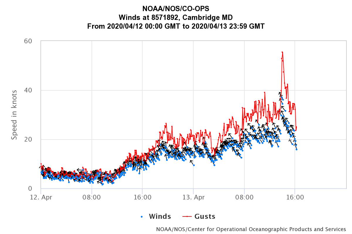
900 Marshy Cove sustained some wind damage today.

~Soffits above the 403 and 410 decks were blown off. Insulation from the attic was blowing around like a snowstorm.

~ A rooftop vent cover blew off along with some singles.

~  The westside front exterior door's hinge was spring when the wind whipped it open.
    (Do not use the east door. It has been secured. Signage in place.)

~ The Cedar Street side reported that wind was blowing rain through their sliding doors.

As of 12:30 PM, It appears that most of the storm has passed. We will see.

Peak gust at 55.5 Knots
Sustained at 35/5 Knots


Friday, September 6, 2019

Where is Dorian? Where is Dorian going?

https://www.cnn.com/interactive/storm-tracker/

It appears that that Delmarva will be spared the wrath of the storm.

Bye-Bye Dorian

Thursday, September 5, 2019

Weather Alert!

ATTENTION OWNERS AND RESIDENTS
THE MOST RECENT STORM CENTER FORECAST SAYS PARTS OF THE DELMARVA PENINSULA WILL EXPERIENCE TROPICAL FORCE WINDS UP TO 50 MPH WITH HIGHER GUSTS TOMORROW AFTERNOON THROUGH TOMORROW EVENING. ABOVE NORMAL TIDES AND STORM SURGE WILL CAUSE FLOODING OF LOW LYING AREAS.

PLEASE REMOVE OUTDOOR FURNITURE, PLANTS AND OTHER ITEMS FROM DECKS, PATIOS AND PORCHES IMMEDIATELY AND SECURE ITEMS THAT CANNOT BE REMOVED.

 BOAT OWNERS, PLEASE CHECK MOORINGS AND ADD EXTRA LINES TO BOATS IN MARINAS. BE READY TO TAKE IN OR LET OUT LINES WHEN TIDES RISE SO BOATS DON'T OVERRIDE PIERS AND BULKHEADS OR LET OUT LINE SO THEY DON'T BECOME SUSPENDED BY THE LINES WHEN TIDES FALL.

Saturday, February 2, 2019

Wednesday, January 30, 2019

Saturday, January 12, 2019

Snow Place Like Home.


NOAA – National Weather Service  REVISED

The National Weather Service has issued a WINTER STORM WARNING for the Mid-Atlantic region.  At the present time, all of the Mid-Atlantic areas can expect between 4” –  8” of snow accumulation starting mid-day Saturday and ending Sunday evening, Jan 13th   in most locations.

Areas in this zone include west of I-95;  Washington, D.C; Montgomery, Howard. Prince Georges, and Anne Arundel counties in Maryland and Fairfax, Arlington, Alexandria, Prince William, Loudoun, Falls Church, and Stafford counties in Virginia.  The Eastern Shore; all of the Delmarva particularly counties of  Talbot, Dorchester, Wicomico, and Worchester of the Delmarva Peninsula will experience snowfall in these locations of between 4” – 8” or more, depending on the track of the storm.  A low-pressure area has moved out of the southwest toward the Mid-Atlantic states.  As it does it will increase the Gulf moisture moving north.

Areas west of I -95 from D.C. and south will begin to see snow showers mid-day on Saturday becoming steady snowfall by the evening and continuing through the night, ending early Sunday morning, Jan 13th .  Affected areas of the Delmarva Peninsula will begin to see snow showers late Saturday evening  Jan 12th  continuing into Sunday, Jan 13th  and ending late Sunday evening.  Southern portions of the Delmarva and Northern Neck of VA as well as the Richmond areas of VA may see between 8” – 10” or higher snowfall amounts.

The path of this event at the present time will also affect locations north of this region including Baltimore City, Baltimore, Harford, Cecil, and Carroll counties.  The storm then is expected to intensify and move toward the East coast where a secondary low may form.  Depending on the intensification, moderate to heavy snow squalls can be expected in the affected areas.  It should be noted that depending on the location of the new low-pressure cell,  locations not presently in the forecast regions of the Delmarva may well experience moderate to heavy snowfall.  Because of the very low temps now over the Mid-Atlantic, road conditions may become hazardous.  This will be heavy wet snowfall.  All areas in the listed locations should prepare for poor road conditions.  Stay tuned to your local NOAA Weather Radio and TV stations for an update.

SOURCE:  NOAA – NWS

                  Sterling, VA Forecast Office

Tuesday, October 9, 2018

NOAA / NWS National Hurricane Center - Advisory #11

Subject: NOAA Hurricane Advisory

NOAA / NWS National Hurricane Center - Advisory #11

The National Hurricane Center has issued the following Advisory to include the Mid-Atlantic region.  At 5:00 a.m. today, Oct 9th, Hurricane Michael was a Cat  2 hurricane (winds of 96 – 110 mph) and was moving NNW toward the panhandle of Florida.  It is expected to be a  Cat 3 hurricane with sustained winds of at least 111 mph with gusts to 120 mph at time of landfall.  Michael is an extremely dangerous cyclonic system and will bring both heavy rainfall and winds in the affected areas.   

The cone of probability places the hurricane moving rapidly NNE toward the outer banks of North Carolina, late Wednesday, Oct 10th.  The cones center forecast places it over the Delmarva peninsula  Thursday morning, Oct 11th.   The U.S. and European models appear to be in agreement with its expected path.  Winds and life-threatening storm surge may affect portions of the South Carolina coastline with tropical force winds between 65 – 73 mph.  The North Carolina and Virginia coastlines can also expect strong tropical force winds and heavy rainfall.  A Hurricane Warning and Storm Surge Advisory may be issued for the coastal sections of SC and NC .  The Mid-Atlantic region of VA and the Delmarva and estuaries may be affected by heavy rainfall and tropical force winds. The affected areas should begin to prepare for this event.  All boating interests should stay tuned to their local TV stations and NOAA Weather Radio for further updates.  Delmarva local interests should take necessary precautions to secure boats and remove any unsecured objects from becoming airborne.

SUMMARY:

Tropical force winds range between 39 - 73 mph and may include all coastal beach locations of  VA and MD.  Storm surge may affect coastal sections of SC / NC.    Flooding in these regions could take place.  These conditions will be accompanied by very heavy rainfall throughout the affected region of the warned areas.  


SOURCE:

NOAA - NWS, National Hurricane Center
Miami, Florida


(special notations have been added)

Tuesday, September 11, 2018

Coastal Flood Warning, September 11, 2018

September 11, 2018 8:00 AM

Coastal Flood Warning in effect until Sept. 11 (10 p.m.)

* LOCATION...Areas adjacent to the Chesapeake Bay on the lower
Maryland Eastern Shore, including tidal tributaries.

* TIMING...Through the high tide cycle late this evening.

* COASTAL FLOOD IMPACTS...Widespread flooding of vulnerable
areas will result in an elevated threat of property damage to
homes and businesses near the waterfront and shoreline. Water
will be 1 to 2 feet above ground level in some areas resulting
in a sufficient depth to close numerous roads and threaten
homes and businesses. Flooding will extend inland from the
waterfront along tidal rivers and bays resulting in some road
closures and flooding of vehicles.

PRECAUTIONARY/PREPAREDNESS ACTIONS...

A Coastal Flood Warning means that flooding is occurring or
imminent. Coastal residents in the warned area should be alert
for rising water...and take appropriate action to protect life
and property. Be prepared for the possibility of road closures
and flooding of properties. If travel is necessary...do not
attempt to drive through water of unknown depth.

Monday, September 10, 2018

NOAA / NWS National Hurricane Center - Advisory #44

Subject: NOAA Hurricane Advisory

NOAA / NWS National Hurricane Center - Advisory #44

The National Hurricane Center has issued the following  Advisory to include the Mid-Atlantic region.  At 5 a.m. today Hurricane Florence is 625 miles SE of Bermuda moving WNW at 9mph as a Cat 2 hurricane with sustained winds of 105 mph with higher gusts.  At the present time, Florence is scheduled to increase its forward speed and strengthen to a Cat 4 hurricane at the time of landfall (Cat 4 ranges from 131 - 155 mph sustained winds) with probably sustained winds of 140 mph, making it an extremely dangerous cyclonic system
with devastating results in the affected areas.   

The cone of probability places the hurricane, with a possible landfall between Wilmington and the outer banks of North Carolina with its southern side to include most of South Carolina.  Landfall could occur Wednesday evening, Sep 12th.  The cones northern side includes the entire Mid-Atlantic region and the Delmarva Peninsula.  Regardless of Florence's eventual track, large swells will begin to affect portions of the U.S. East Coast today, resulting in life-threatening surf and rip currents.  There is still uncertainty withFlorence's exact track.   However tropical force winds extend out up to 140 miles from its center with the Delmarva Peninsula within that sphere.
Tropical force winds range between 39 - 73 mph and may occur that would include all coastal beach locations as well as the western shore of the Chesapeake Bay beginning early Friday morning, Sep 14th.  Flooding in western sections of the Bay may also occur.  These conditions will be accompanied by very heavy rainfall throughout the Mid-Atlantic .  Rainfall amounts will range from 8" - 10" or more.  Preparations should begin now with the removal of outdoor furniture and other loose items that could become airborne. Boating interests in the Mid-Atlantic region and the Eastern Shore should take precautions to secure boats or move them to safe locations.  A State of Emergency has been declared in NC, SC, and VA.

Major flooding can be expected in the Washington - Baltimore metropolitan areas.  With the recent heavy rains, tree root systems will have been
weakened and vulnerable to falling, creating danger to power lines.   All
areas within the cone of probability should monitor their local TV and radio stations as well as NOAA Weather Radio for updates as they become available.

SOURCE:

NOAA - NWS, National Hurricane Center

Miami, Florida

Wednesday, March 7, 2018

High, Higher, Higheest Tide!

Photos at High tide at 8:06 AM.  The marina finger piers are submerged.

Tide charts are available at NOAA - CAMM2


So far it is a 6 foot 5 inch rise since last Saturday's low tide.
 This may be the second highest tide since Isabel.
 

Saturday, March 3, 2018

And then there was W-I-N-D !

Yes, the wind whistled all day on Friday and continues on Saturday.

Folks have been asking about flooding. Actually, the opposite happens in the bay. Whenever the wind blows hard from the north, the Chesapeake will have exceptionally low tides.  Several boats are now hanging on their dock lines. The safety ladders in the DH Marina are out of the water by more than one foot. That's about as low as it gets. 
Photo taken one hour before low tide

Hanging on its cleats

Wind is another story. Many of the Townhouses here have blow-offs. Nothing too serious, but, enough to foster leaks if not fixed before the next rain.  Sentry is on the case.  Replacement shingles are on order.  Cattail Cove and Marshy also had several blow-offs.  Fascia capping has also been lost.

Townhouse One lost some fascia but their laminated shingles fared better in the high winds.
TH5 Shingles lifting in the wind


Saturday, February 10, 2018

The future of Dorchester County: High Tide

Here's a video regarding the trend and fate of Dorchester County.  Multiple images of Cambridge are included.

Yes, that's Deep Harbour and the Municipal Marina.

"High Tide in Dorchester" from Chesapeake Bay Journal on Vimeo.
The video is available for your viewing pleasure at https://vimeo.com/252911985 

If you like this video, make sure you share it, too!


December, 2012

Tuesday, January 24, 2017

A Nasty Day on the Choptank

The View from Long Wharf
January 24, 2017
NE Winds 40-50 MPH 
Surf's UP!


Thursday, December 15, 2016

Cold Weather: Freeze Warning!

All residents, owners, board members,

We have extremely cold weather headed our way with temps steadily falling from now thru Friday morning before slowly starting to rise. Please contact owners of known vacant units to insure heat is on if you know how to reach them.

It was discovered last week during a move-in the gas was turned completely off in one unit. It may have been warm enough to prevent freezing up to this point but anyone having unheated units from now on stands a pretty good chance of having pipes freeze and burst.

A minimum thermostat setting of 60-63 degrees F is recommended for vacant units. 

Stay safe and warm.

Andy, Sentry Management

If you are off site and need someone to tend to your unit, 
send an email or call Sentry Management,
cambridge@sentrymgt.com    410-221-0398
or send an email to mc900@comcast.net


Friday, September 30, 2016

Matthew, Maybe.................Maybe Not,

A Message from Sentry Management: 
Please see the below weather update regarding Hurricane Matthew.  While it is still way too early to predict exactly what track this storm will take, we feel it is the best interest of all of you to begin to put information out regarding this storm.  Those of you that are weekender’s, it is a good idea to start making your storm preparations now in the event you cannot make it back to your home prior to any storm impacts. 

We recommend you do the following:
  • Place any furniture on your balcony or patio inside or secure it to something.
  • Those of you with boats should also double up your lines to ensure they stay in place. 
  • Any loose items in your yard should also be stored.
  • Grill covers should be either secured tightly or removed entirely. 
  • Trash cans should be stored. 


As we receive additional information we will be sure to pass it along to all of you.

Major Weather Event:

The NOAA National Hurricane Center is tracking a Tropical Storm “Matthew” presently  located south of the Dominican Republic.  The NOAA models, as well as the European Model; indicate that the storm will begin to turn north on Sunday, Oct 2nd.  Then move over the Bahamas toward Florida.  At this point the storm is predicted to become a Category II hurricane ( sustained winds 96 – 110 mph and storm surge of 6’ to 8’ ).  The models indicate that the hurricane would move along the east coast passing just off Cape Hatterus, NC on or about Wednesday, Oct 5th.  There are a number of factors that would affect the path of the storm including a cold front moving in from the west.  However, if the storm continues along the forecast track, Matthew would begin to affect the Delmarva on or about Thursday, Oct 6th .  The wind field with this level of storm would bring tropical force winds into most of the Eastern Shore (60 + mph in gusts).  Heavy rainfall (3” – 5” ) can be expected and could include the western shore – D.C. &  Baltimore,  Mid- Atlantic region.  As the track becomes more defined, additional notices will be sent.  Stay tuned to your local news outlet as time progresses.

Source:  NOAA, National Hurricane Center
               Miami, Florida


Todd W
Division Vice President
Sentry Management Inc
2200 Defense Highway, Ste 405
Crofton, MD  21114
(410) 721-7171 ext. 57001
(410) 721-3842 (fax)

Friday, September 2, 2016

Hermine approaches Delmarva; September 2, 2016

As of 8:00a.m.  Sept 2nd  Hurricane Hermine has now been downgraded to a tropical storm.  It has sustained winds of nearly 70 mph and is moving north northeast at 15 mph, centered just east of Charleston, SC.  The present storm track will place it at or near the Outer Banks, NC by Friday evening with winds 60 + mph in stronger gusts.  It will then move north just off the Delmarva peninsula by mid-day Saturday, Sept. 3rd.   NOAA models and the European model are still not in agreement as to what happens next.  It does appear that the storm will stall at this point and then may move west toward the coastline between Maryland and New Jersey.  Additionally, it may become  extra – tropical as a strong Nor’easter and remain in the same location until the middle  of next week.  This could cause extensive beach erosion  along with very heavy rain that could include the Baltimore – Washington area.  Rainfall amounts with this scenario would be between 5” – 8”  in squalls on the Delmarva and 3” – 5” over the Mid-Atlantic region, along with winds 30 – 40 mph or higher.  The elements that are affecting this is one, a strong high pressure over New England with its clockwise circulation and  two, the counterclockwise circulation of the storm with their two wind fields both moving toward the coastline.  All interests in the Mid-Atlantic region should stay tuned to your local TV station and NOAA Weather Radio for updates as this event unfolds.

The tidal levels displayed do not include the effects of the impeding storm.
2.0 feet is the MHHW (Mean High-High Water)
Source:  NOAA, National Hurricane Center,  Miami, Florida